Description
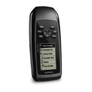
Garmin GPSMAP 65 Handheld GPS Navigation
System Overview
The Garmin GPSMAP 65 is a personal GPS device designed to provide navigation assistance for outdoor activities. It comes with a base map and can add additional maps. The device is pre-installed with TopoActive Europe maps, which are routable, allowing users to easily navigate through various terrains.
One notable feature of the GPSMAP 65 is its waterproof protection. With an International Protection (IP) code of IPX7, it can withstand immersion in water up to 1 meter for 30 minutes, making it suitable for use in wet environments.
Equipped with an electronic compass, the device provides users with accurate directional information. The built-in display uses TFT (Thin Film Transistor) technology and has a diagonal measurement of 2.6 inches. The display size is 36 x 55 millimeters, with a resolution of 160 x 240 pixels, ensuring clear and detailed visuals.
In terms of memory, the GPSMAP 65 has built-in memory, allowing users to store and access data conveniently on the device.
Overall, the Garmin GPSMAP 65 is a reliable personal GPS device with the ability to add maps, including the pre-installed TopoActive Europe maps. Its waterproof protection ensures durability in wet environments, while the electronic compass and TFT display technology enhance navigation and visual experience. With its built-in memory, users can conveniently store and access data on the device.
Features
Expanded GNSS Support
Multi-band technology and expanded GNSS support (GPS, GLONASS, Galileo, QZSS, and IRNSS) provide optimal accuracy in steep country, urban canyons, and forests with dense trees.
ABC Sensors
Navigate every trail with ABC sensors, including an altimeter for elevation data, a barometer to monitor the weather, and a 3-axis electronic compass.
Preloaded Topo Maps
Preloaded TopoActive U.S. and Canada maps show you terrain contours, topographic elevations, summits, parks, coastlines, rivers, lakes, and geographical points.
Public Land Boundaries
An optional display of federal public land boundaries on topographical maps helps you know that you’re venturing where you’re supposed to be.
Smart Notifications
Receive emails, texts, and alerts right on your handheld when paired with your compatible device.
GARMIN Explore App
Plan, review, and sync waypoints, routes, and tracks by using the Garmin Explore app and website. You can even review completed activities while still in the field.
GEOCACHING
Get paperless geocaches by uploading GPX files straight to your device. View key information such as location, terrain, and hints from Geocaching.com.
MICROSD™ Slot
Using your compatible device and microSD memory card, conveniently download TOPO 24K maps and hit the trail, or access HuntView Plus maps to see public land types and boundaries as well as private landowner names and boundaries.
Go to the store.

")